
By Jonathan Ingraham, Michael Braithwaite | The Gazette
'I've got some cattle whose feet are going to fall off, their backs so burnt that their hide is cracking and breaking,' one rancher said.
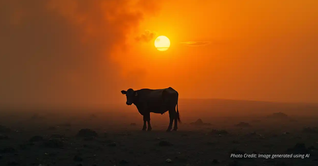
Cattle feverishly mooed in the middle of the early August night, an unusual sound to hear at that hour.
Their unease was brought on by the Lee fire, which was quickly encroaching upon their enclosure at the 103-year-old Halandras family ranch, about 23 miles south of Meeker.
The wildfire that started from lightning strikes on Aug. 2 was devouring prime northwestern Colorado grazing land that the family — and other ranchers — rely on faster than emergency crews could contain a stable fire line.
Regas K. Halandras recalled family members and ranch hands jumping into action for some “midnight cowboying” that night as they corralled the herd. The sky above them glowed orange and red, smoke billowing skyward from the burning sagebrush.
“Luckily, my brother’s cows were evacuated before the ranch burnt,” Halandras said. “We moved them after midnight just before the fires moved in.”
The Halandras family has been ranching sheep or cattle in the White River Valley for a century at its ranch near the intersection of Colorado Highway 13 and Rio Blanco County Rd 5 — the southeastern edge of the Lee fire’s boundary.
Regas, now 60, has been working at the ranch since his teenage years.
“We were told we couldn’t go in and get the cows at first,” he said, recounting his experience while officials were still gathering information about the fire. “But about 10 p.m., they gave us the OK. Sure, I was happy to do it in day time, no problem, but when they call and say go, you go.”
Regas said that even though the family operation is a smaller ranch — only around 100 cattle — the grazing lands atop the Roan Plateau, where the Lee fire burned, are vital not only to them, but also to the other families and ranchers raising Hereford and Black Angus cattle breeds.
Colorado year-to-date wildfire acreage
| Fire | Location | Incident Created Date | Colorado Acres |
|---|---|---|---|
| Colorado Total | 232,527 | ||
| Lee | 11 Miles SW from Meeker, CO | August 3, 2025 | 137,758 |
| Turner Gulch | 8 Miles NE from Gateway, CO | July 10, 2025 | 31,699 |
| Elk RBX | 10 Miles SE from Meeker, CO | August 2, 2025 | 14,519 |
| Stoner Mesa | 11 Miles NE from Dolores, CO | July 29, 2025 | 10,249 |
| Derby | 13 Miles N from Dotsero, CO | August 17, 2025 | 5,447 |
| Twelve | 3 Miles NE from Elk Springs, CO | August 6, 2025 | 4,287 |
| South Rim | 9 Miles E from Montrose, CO | July 10, 2025 | 4,232 |
| 31 North | 13.5 miles North of La Junta Colorado | March 18, 2025 | 3,108 |
| Deer Creek | 1 Miles N from Old LaSal, UT | July 10, 2025 | 2,597 |
| South Meridian | 5 miles East of Colorado Springs CO | March 13, 2025 | 2,516 |
| US 160 | 13 miles east of Kim, CO | April 7, 2025 | 2,275 |
| Sowbelly | 16 Miles W from Delta, CO | July 10, 2025 | 2,274 |
| Crosho | 8 Miles NW from Yampa, CO | August 11, 2025 | 2,073 |
| Andrix | 20 miles East of Kim Colorado | March 11, 2025 | 1,938 |
| Iron Ladies | None entered | March 17, 2025 | 1,451 |
| 31 South | 13 miles North of La Junta Colorado | March 18, 2025 | 977 |
| Horse Draw | 24 Miles E from Dinosaur, CO | June 26, 2025 | 750 |
| Colowyo | 30 Miles SW from Craig, CO | June 20, 2025 | 587 |
| Ute 63 | None entered | July 14, 2025 | 534 |
| Wright Draw | 8 Miles NE from Gateway, CO | July 11, 2025 | 465 |
| Hilltop | 7 Miles SE from Rifle, CO | June 26, 2025 | 329 |
| Cottonwood Flat | 2 Miles E from Parachute, CO | July 17, 2025 | 311 |
| Elkhorn | 18 Miles N from Durango, CO | July 26, 2025 | 298 |
| Spencer | None entered | June 29, 2025 | 237 |
| Waters Canyon | 14 Miles SW from Mancos, CO | August 2, 2025 | 208 |
| Leroux | 5 Miles N from Hotchkiss, CO | August 3, 2025 | 195 |
| La Plata | 4 Miles W from Twin Lakes, CO | August 18, 2025 | 133 |
| 387 | None entered | April 28, 2025 | 118 |
| Coulter Creek | None entered | August 3, 2025 | 107 |
| Jack Springs | None entered | August 2, 2025 | 104 |
| Rim Road | 8 Miles SW from Ignacio, CO | July 26, 2025 | 95 |
| Cottonwood Creek | None entered | June 21, 2025 | 83 |
| Oak | None entered | August 10, 2025 | 70 |
| Daniel Road | None entered | April 18, 2025 | 53 |
| Bear Canyon | 20 Miles NE from Dinosaur, CO | July 6, 2025 | 47 |
| Pinon Hills | None entered | July 11, 2025 | 47 |
| Little Cimarron | None entered | July 11, 2025 | 44 |
| Freeman | None entered | May 25, 2025 | 38 |
| Fault Line | None entered | May 26, 2025 | 34 |
| Yellowjacket | None entered | August 15, 2025 | 24 |
| Maverick | None entered | August 4, 2025 | 22 |
| Kurth | 3 Miles W from Greystone, CO | July 6, 2025 | 21 |
| Enoch | None entered | August 3, 2025 | 20 |
| 314 | None entered | February 13, 2025 | 20 |
| Ridge | None entered | June 17, 2025 | 16 |
| Bunkwater | None entered | July 31, 2025 | 14 |
| Hay | None entered | June 5, 2025 | 13 |
| Dry Gulch | None entered | January 21, 2025 | 12 |
| Flat | None entered | April 7, 2025 | 10 |
| Red Canyon | None entered | June 18, 2025 | 9 |
| Canyon | None entered | April 10, 2025 | 9 |
| talbot | None entered | August 12, 2025 | 7 |
| Ladore Camp | None entered | July 1, 2025 | 6 |
| Baxter | None entered | August 22, 2025 | 5 |
| South Arkansas | None entered | March 26, 2025 | 4 |
| 4000 Block | None entered | February 5, 2025 | 4 |
| Grape Creek | None entered | June 26, 2025 | 4 |
| 285 | None entered | February 11, 2025 | 3 |
| Holms Mesa | None entered | July 6, 2025 | 3 |
| Callan Draw | None entered | August 2, 2025 | 3 |
| Logging | None entered | July 27, 2025 | 2 |
| 321 Command | None entered | June 19, 2025 | 2 |
| Sandwash | None entered | July 7, 2025 | 2 |
| Rabbit | None entered | March 5, 2025 | 1 |
| Horse Mesa | None entered | June 1, 2025 | 1 |
| County Rd Z/6 | None entered | April 10, 2025 | 1 |
| Monument Gulch | None entered | June 3, 2025 | 1 |
| Range | None entered | July 4, 2025 | 1 |
| Ute | None entered | May 24, 2025 | 1 |
| Hard away | None entered | March 24, 2025 | 1 |
| Farnham | None entered | August 6, 2025 | 1 |
| Rawah Fire | None entered | July 28, 2025 | 1 |
| Sioux | None entered | August 8, 2025 | 0 |
| Wells Gulch | None entered | June 20, 2025 | 0 |
| Horse Mountain | None entered | May 9, 2025 | 0 |
| Bare Hills | None entered | April 8, 2025 | 0 |
| C 41 | None entered | June 17, 2025 | 0 |
| 16 Road | None entered | June 23, 2025 | 0 |
| Lone Pine | None entered | August 21, 2025 | 0 |
| Lewis Creek 2 | None entered | July 30, 2025 | 0 |
| Parkdale | None entered | July 26, 2025 | 0 |
| Trail Gulch | None entered | May 26, 2025 | 0 |
Throughout its burn, the Lee fire consumed 137,758 acres of land, making it the fifth-largest wildfire in state history.
Colorado’s wildfire season in 2025 has been the worst since 2020, according to statistics collected from the National Interagency Fire Center. More than 232,527 acres of land has burned in the state so far this year, but, luckily, there’s been no fatalities and no where near the structures damaged or destroyed as large fires of previous years, such as the Marshall fire or the East Troublesome fire of 2020.
Colorado wildfire burn area worst since 2020

Chart: Evan Wyloge•Source: National Interagency Fire Center (NIFC) •Get the data•Created with Datawrapper
Ranchers’ businesses burned by the Lee fire
Rancher’s operations and the land they use, whether private or permitted through the Bureau of Land Management, come with several overlooked costs built into their work, Regas said.
One of those costs is the price of hay, which cattle consume during the colder months of late fall, winter and early spring on ranching properties, as the grazing fields up high are not fully accessible.
“Ranchers depend on the land for summer grazing,” Regas said. “If they lose summer range land due to fire, they have to bring livestock down to open meadows earlier, feeding them ahead of schedule, like through October or more, into December or later.”
READ THE FULL ARTICLE AT THE GAZETTE